Further to the Timber Harvest Notice issued by the https://grca.on.ca/media-releases/timber-harvest-season-begins-again/, the Oak Ridges Moraine Trail through the West Forest, from Parking Lot P2 to the Ganaraska Forest Centre, will be temporarily closed until March 1, 2026.
Due to the nature of the timber harvest operations, the Oak Ridges Trail Association (ORTA) is currently unable to provide an alternate route through the West Forest.
End-to-end hikers who require this section to complete their journey are advised to postpone completion until March 2026.
If you have any questions or concerns, please contact us at:
trails@oakridgestrail.org
Thank you for your understanding and cooperation.
Ganaraska Forest Timber Harvest Season Begins Again - Ganaraska Conservation
Ganaraska Forest Timber Harvest – Trail Closures in Effect
The Ganaraska Region Conservation Authority (GRCA) has commenced its annual selective harvest of Red Pine plantations in the West Forest, with operations expected to continue until February 28, 2026. This initiative supports the growth of native species such as Red Oak, White Pine, and Sugar Maple.
Trail Impacts:
- All recreational trails within active logging areas are closed for public safety.
- Rolling closures will be implemented as operations progress.
- Trails will reopen once GRCA staff verify safe conditions.
- Pink flagging tape marks trails within harvest zones to help protect them.
- Yellow caution tape indicates active logging routes—please reduce speed and yield to equipment.
Visitor Guidance:
- Avoid logging staging areas and follow posted signage.
- Use the Ganaraska Forest Trails Map to plan your visit and steer clear of affected zones.
- For questions, contact GRCA at 905-885-8173 or info@grca.on.ca.
We appreciate your cooperation in keeping the forest safe for all users and supporting sustainable forest management.
Ganaraska Forest Timber Harvest Season Begins Again
FOR IMMEDIATE RELEASE (Oct. 1, 2025): The Ganaraska Region Conservation Authority (GRCA) completes scheduled, selective harvest of Red Pine plantations in the Ganaraska Forest each year.
These logging operations, guided by the Forest Management Plan, facilitate the growth of native tree species, like Red Oak, White Pine and Sugar Maple, all of which were included in the initial landscape restoration plans when the Forest was being planted over 80 years ago.
Click here for more details including trail closures
Effective September 1, 2025
Thanks to the generosity of a private landowner, the Oak Ridges Moraine Trail has been re-routed through their property in Clarington East. This change removes a short section of the main trail from the roadside, improving the hiking experience.
Additionally, the former main trail south of Beaucage has been reblazed and incorporated as an extension of the Bluebird Side Trail.
Please refer to the updated map for details.
Thank you to all our landowners for supporting the Oak Ridges Moraine Trail!

The Oak Ridges Trail through the Mary Lake property will remain closed until the Fall 2026. Additionally, please note that this will include the Ed Millar Side Trail west of Keele Street.
The Pine Farms Side Trail at the corner of Jane Street and the 16th Sideroad remains open. If you are interested in purchasing a hardcopy of the Oak Ridges Trail Guidebook please visit our website or email guidebook@oakridgestrail.org
Due to the temporary closure of these trails, here is the recommended alternate route for End-to-End (E2E) hikers:
Travelling east from Jane St go south on Jane to the entrance into MaryLake. Follow the main trail east until you reach the Pine Farms side trail. Go north on the Pine Farms side trail to the 16th. Go east on the 16th to Dufferin where you again join the main trail. Reverse this for hikers going west. The 16th is hilly, but the speed limit is 40km/hr.
ORTA Map 8 - Trail Re-route near Hwy. 35/115 in Clarington and new End-to-End route
As of March 11, 2025, the Oak Ridges Trail will have a gap near Hwy. 35/115.
Hikers are asked to refrain from crossing private property to enter the Ganaraska Forest.
The trail will end at the large parking lot on the west side of Hwy. 35/115, indicated by either of the ‘P – parking’ spots on the Guidebook map.
The trail will also end at P2 (parking area) in the Ganaraska Forest, east of Hwy. 35/115, indicated by the ‘P – pay’ on the Guidebook map near Boundary Road.
This gap and re-route will not affect those completing their end-to-end challenge. Please do not go through the tunnel at this time.
The Oak Ridges Trail Association is working to obtain permission from property owners. Until then, please adhere to the re-route.
ORTA End-to-End trail route in the Ganaraska West Forest (SEE MAP):
- Please follow the route P2, WF15, WF25, WF33, WF34, WF41, WF40, WF50, WF57, WF58, to WF67, follow Fire Route 101 to the Ganaraska Forest Centre (or do this in the reverse). Please use the Ganaraska Forest Map on their website or download the app Field Map and download the Ganaraska Forest Map.
IMPORTANT – The Ganaraska Forest requires all users to have an individual Forest pass. Please check the Ganaraska Forest Map frequently for trail status updates and interruptions.
ORTA Map 9 Trail Re-route - Municipality of Port Hope - new End-to-End route
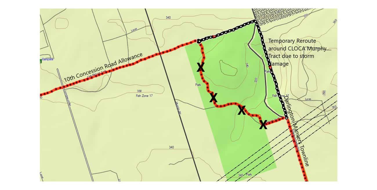
As of March 11, 2025, east of Walker Road, the Oak Ridges Trail will proceed east/west along the 10th Line to Wright Road.
Hikers are requested not to enter the Ganaraska Forest east of Walker Road to Robb’s Hill (*8 on the Guidebook map). The section of trail at Robb’s Hill is private property.
The Oak Ridges Trail Association is working to obtain permission from property owners. Until then, please adhere to the re-route.
(April 23, 2025)
The trail is now open between Keele St. and Dufferin St.
(Mar 8, 2025)
Much of the work of building new boardwalks on the trail has been done, although they are still fenced off to prevent access.
The old, dangerous bridge as you walk in from Keele has been replaced.
I have asked for an update from Seneca as to when the trail will be officially open, but in the meantime I will go and have a look whenever I can, and update this page with any news. (Steve Fisher)
(Sept 19, 2024)
Due to the temporary closure of these trails (see below), here is the recommended alternate route:
Travelling east from Jane St go south on Jane to the entrance into MaryLake. Follow the main trail east until you reach the Pine Farms side trail. Go north on the Pine Farms side trail to the 16th. Go east on the 16th to Dufferin where you again join the main trail. Reverse this for hikers going west. The 16th is hilly, but the speed limit is 40km/hr.
(Sept 2, 2024)
Temporary Trail Closures - Mary Lake and Seneca (King campus)- the main ORTA trails through both concessions will be closed until further notice due to construction. The Mary Lake trail may reopen in the fall, but the Seneca trail is expected to be closed until the New Year.
Seneca is installing Armor stone and removing sections of the board walk that will be replaced. This section of the trail (L4-1 and L4-2) is temporarily closed. SEE MAP

(November 2024)
York /Durham Townline to Concession 2.
This 2 km section of trail is a challenging route due to tree roots, irregular trail surface and seasonally wet conditions with occasional trail flooding. Boardwalks and bridges have been installed where practical. The route is a scenic wilderness trail passing through cedar lined areas and occasional marshlands.
Roadside parking for a small number of cars is best on Concession 2.
(October 30, 2024)
The Yeo Side Trail, Map 8 Clarington East, is closed due to vandalism of signage and blazing markers. This might become permanent if no reasonable solution is found.
ORTA Map 8 – Ganaraska West Forest - important parking changes
Effective Oct. 23, 2024, the roadside parking location at MacMillan and Langstaff Roads is no
longer available. Please ‘x’ out that parking location on your map. Please only use designated
parking areas as noted on the Ganaraska Forest Map. Parking is identified by blue circles.
IMPORTANT – The Ganaraska Forest requires all users to have an individual Forest pass.

Route is now apx 1.4km.
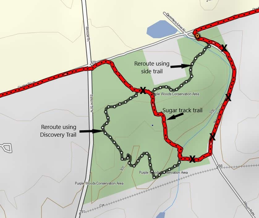
Area is now permanently rerouted. This is to allow for natural regeneration. Route is now apx 1.3km. See map here. See closer detail map here
(a) Ganaraska Forest requires all users to have an individual Forest Pass, even if following the Oak Ridges Moraine Trail. Information & online passes available at: ganaraskaforestcentre.ca Be aware that there is an ongoing process of trail changes and signage / blazing markings. This might have an effect on navigating ORMT route. So, heads up and patience. Please report any issues to ORTA.
East from Palgrave on the Caledon Trailway, we now continue on the Trailway east of Mount Pleasant Rd to Mount Wolfe Rd. It is 2km between the two distant markers. This update takes us more off-road. See map reroute HERE.
The Trail Hub 722 Chalk Lake Rd. Uxbridge, ON L9P 1R4 There is a pay-per-use fee. Currently $6 per person per day. Please visit: https://www.trailhub.ca/index.php/about/pay-per-use-2022.
Uxbridge Trailhead Parking Revenues to Sustain Trails and Local Amenities. Permit parking is being implemented at all trailheads in the Durham Region Forest area and trail-head along Conc. 6 and 7. Daily parking permits will cost $6.00 per day. All funds collected from parking revenue will be directed towards trail improvements. Frequent users of trail-heads will be able to purchase yearly parking passes for $75, and Township of Uxbridge residents will be able to obtain a permit at no charge by registering on the parking system. Learn more click here
Free Parking in Uxbridge is still available at the following locations:
1- conc. 2.- roadside, future parking lot at the Rouge Park Coyote Trail south of Webb Rd)
2- conc.3-roadside/Goodwood Tract TRCA, parking lot/Secord Forest
3- conc.4- roadside
4- Brock Rd- parking lot/Pleasure Valley/Pathways, parking lot/Brock Tract TRCA.
Northumberland Forest Map shows R roadside parking at Bowmanton Road west of Beagle Club Rd. This is no longer allowed. Vehicles may be tagged and towed Referencing By Law 21-10.
Correction to a Trail Distance Point between Dufferin and Bathurst St. is 2km not 3.8km
Correction to Map 3B Hwy 404 was inadvertently marked as Hwy 400 :
Main Route runs along 18th Sideroad between Concession 10 and 11 and not through landowners property. May 2021 after edition 7 print.
Map 10 Hamilton and Map 11 Northumberland Forest in the new edition 7 guidebook HAD incorrect Trail Distance Points (TDP). If you purchased the guidebook from a retailer and require the corrected map please notify the office by email and a new Map 10 and 11 will be mailed to you at no additional cost. (info@oakridgestrail.org) . The correct maps have 2021 in the bottom corner.